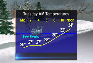
It should start off as a little sleet and freezing rain mixed before changing to all freezing drizzle and freezing rain. Slick conditions will greet most morning commuters with a glaze to up to 0.1" of ice in central Iowa.
Once temps warm up above freezing around 9 or 10am, the roads will become mainly wet and travel will improve. Rain showers and even some rumbles of thunder are possible with this storm for the rest of our soggy Tuesday. Keep track of any changes with ABC5 Weather.
The whole storm system will wrap up with some light snow accumulations early Wednesday in northern Iowa. Most of us will see 1/3" to 3/4" of beneficial water with this storm. There is very little frost in the ground so this system should help the rainfall deficit with another soaking rain.
The wind will become a factor on Wednesday! Don't be surprised to see fowl weather with winds 20 to 30mph with gusts up around 50mph from the WNW! Take care and add about twice as much time to your Tuesday commute so you can slide into work safely tomorrow!
No comments:
Post a Comment